The Same River, Twice .
Torrential Urbanism, 2017
PetaBencana.id Group, Indonesia
@ Urban Risk Lab, MIT
The immersive video installation The Same River, Twice narrates the story of PetaBencana.id, an online platform and disaster-mapping project for reporting flood events in Jakarta, Indonesia. Focusing on user narratives, the perspectives of risk-affected residents, and river ecologies within the city, the installation utilizes video documentation that portrays Jakarta as a megacity struggling to adapt to climate change during the tropical monsoon season.
Like many other megacities in South and Southeast Asia, Jakarta is situated in a coastal delta plain. Traversing the city from north to south, the Ciliwung River defines the central – and littoral – spine of the city. Over the past three decades, the hyper-urbanization of Jakarta has changed the nature of both the river and its relationship to the city.
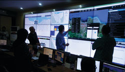
PetaBencana.id is a community-led, open-source map; the project is supported by the Humanitarian Infrastructures Group of the Urban Risk Lab at MIT School of Architecture and Planning, with the aim of further developing CogniCity Open Source Software as a free platform for emergency response and disaster management. As megacities in South and Southeast Asia become increasingly complex systems of people and interconnected infrastructures, extreme weather events and long-term environmental changes pose acute challenges for disaster response and humanitarian action.
Although rapidly urbanizing environments are often thought to be “data scarce,” by enabling residents to share emergency data openly and in real time, PetaBencana.id makes available a wealth of information that promotes resilience to extreme weather events. By gathering, sorting and visualizing data, it provides critical information for residents, communities, and government agencies. The platform adopts a “people as sensors” paradigm, whereby confirmed reports are collected directly from the users at street level, removing expensive and time-consuming data processing. This framework creates accurate, real-time data which is immediately available for users and first responders.
PetaBencana.id, a project initiated in Indonesia by the Urban Risk Lab at MIT, consists of a multidisciplinary team from the fields of design, planning, geomatics, computer science, and philosophy. The team combines design and implementation, bringing into action knowledge from both ethnographic and data-based research through operational web-based programming. By investigating the social consequences of infrastructure transformation as a result of rapid development and climate change, this research project develops new tools, techniques, and methods to help democratize processes of urban transformation and enable greater resilience to climate change.
 |  |
|---|